Drone Use in Construction Marketing

The use of drones in construction is growing rapidly, with companies in this industry using drones for various tasks throughout the construction process. We count several construction companies as our clients, and here we are breaking down the uses of drones and other tools for construction services marketing.

The most common use of drones in construction is for marketing, because aerial photography and video showcase project site progress, action on the site, and the finished project better from the bird's eye view than from the ground. You can see more from the aerial view and show off the scale of the project, and the best way to get this type of content is to have ongoing construction progress documentation using drones.

How do construction companies use drone photography and video for construction marketing?

  1. Social Media Content

Construction aerial photography and video generate great content to showcase the progress on the construction site to stakeholders and the public. They can also be used as early-stage marketing for the brokers if the building needs to be leased by tenants. Below are some examples: before/during photo and video clip that was posted on social media by our clients.

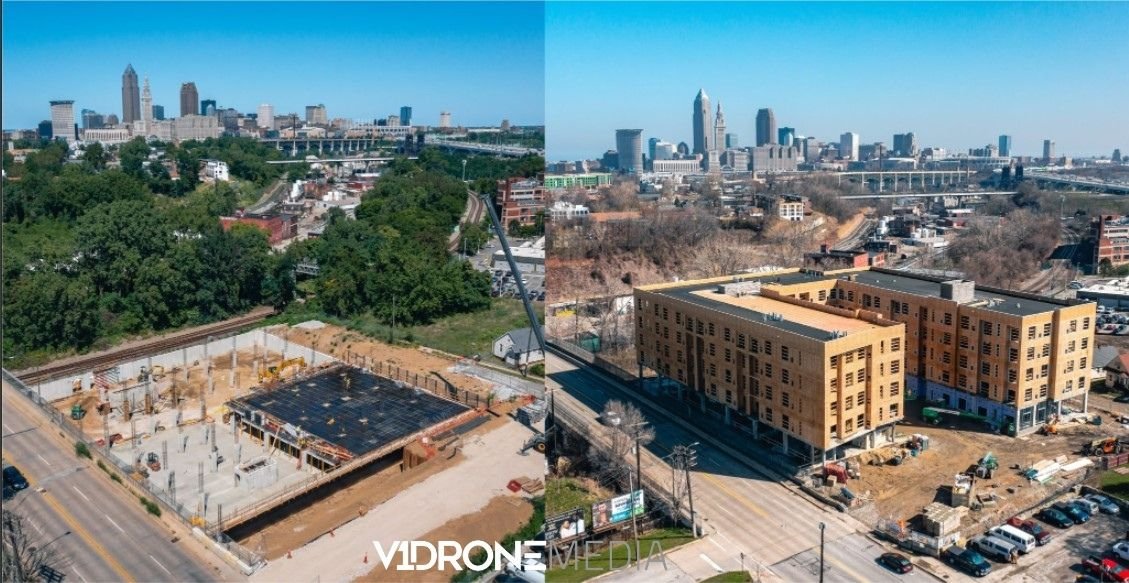
Before/During drone photo of a construction site on West 25th Street in Cleveland

2. Project Portfolio Showcase on Construction Company Website or YouTube Channel

Every construction company should have a section on their website to showcase the projects that they have been involved in. What better way to showcase them than with photos or videos of finished projects, maybe even an impressive hyper-lapse or timelapse video of the building going up during the construction?

3. Customer Proposals, Presentations, Business Development

While not all scopes of work require to have visual updates of the construction site, having this type of deliverable throughout the construction process may enhance your proposal, and even take it over the top all things being equal among the other bidders. Especially if the construction client is not local, which is often the case.

We have a construction client whose building owner is overseas, and having consistent visual updates is very valuable to them. It gives transparency and increases their confidence and trust in the builder.

4. Video Web Banners on Construction Company's Homepage

Have you heard that the website homepage, which is most often the landing page, is the most important page to optimize the content on because it gets the most traffic, and that's where the visitors decide if they want to browse further? A video banner of prominent projects that the construction company has built will impress many viewers and increase their confidence and motivation to take the next step: browse more or contact the builder. Here is an example.

Video is becoming a very important part of marketing strategy for many industries, including construction marketing strategy. If you'd like to know more about the reasons why read our blog post Why Is Video Important For Your Marketing?

What is the Return on Investment (ROI) of construction site progress monitoring and documentation?

Many construction companies leverage drones and other visual technology tools for more than just marketing, such as for enhancing customer communications, internal project updates, construction site security, and re-creating the built environments in BIM (Building Information Modeling) and creating digital twins.

In addition to drones, these tools are time-lapse cameras and 360 virtual tours. The visual output of these tools over the lifecycle of the project can be used and reused for various purposes, which can make the acquisition cost of construction site imagery very efficient, and its Return on Investment (ROI) increases with every use.

These tools are within the digitization trend in construction, facilities management, and other industries. This imagery can be used to re-create the built environment in 3D in BIM (used for construction and design) or as digital twins (usually used for facility maintenance and operations) to give companies a complete 3D visual model of the build. It is a digital documentation record that can be accessed at any time to send information about the building, reflect changes with its physical counterpart, and allow for materials ordering and scheduling (in the design/construction stage or for maintenance and expansions if the building is operational). These types of digital models can replace final building drawings and operations manuals.

We outline more drone uses on construction site on our blog post Top 4 Drone Uses in Construction Site Management.

If you'd like a quote for construction progress monitoring job or consultation on what equipment is best to use on your construction site for a specific purpose or a variety of uses, contact us!

Top Drone Applications in Construction Project Management

Many people don't think of drone uses beyond military applications or taking aerial pictures and video for professional photographers, videographers, and filmmakers. The truth is many industries are adopting this multi-use tool at very fast rates, and using drones for construction project management and site visualization is a top trend in the construction industry, according to Project Manager News.

Here are the top 4 drone uses for construction projects

1.   Construction Project Management via Construction Site Visualization

Drone photos and videos taken and shared at regular intervals for construction monitoring to verify progress, changes, and comparison vs. design documentation can improve communication and decision-making between the construction project management team members. When they are looking at the same pictures or video vs. written or verbal reports from several people walking the construction site at different times, there is a lot more clarity and agreement on the state of the site's progress, leading to faster problem identification and decision-making.

360 video and photo technology, when combined with drones can help produce virtual construction site tours (with interior and exterior of the building, see our example here) that can be used for touring the site virtually by team members, customers, or owner's reps, which gives transparency on the project progress, can help resolve conflicts, and speed up decision making.

Site mapping using drone photogrammetry software can be performed in all stages of construction, overlaying processed drone site maps with site plans for utility, wastewater, equipment location, etc.), helping with planning and managing the site.

2.     Drone Inspection (Building, Façade, roof, Equipment)

Remote drone inspections performed by qualified drone pilots can replace hours of human time spent inspecting and tracking the state or location of equipment, structures, and critical assets, decreasing the likelihood of employee accidents and human error when gathering this data visually by walking the site or climbing structures, leading to a more efficient, safer, and cost-effective operation.

Proven drone photogrammetry scanning software such as Drone Deploy, Pix4D, AgiSoft (and others) offer tools to upload and process point cloud data gathered by a drone pilot in a matter of hours, giving real-time actionable information in form of hi-res images and digital twins of structures (3D aerial photogrammetry models) for someone to conduct an inspection in the safety of their office, and provide collaborative tools for the construction team to document photographic evidence and make notes on "problem" areas.

3.     Construction Site Documentation

You can document as-built conditions upon the completion of the project via panoramic photo and video virtual tours, site maps, and 3D model creation that can be integrated into BIM (Building Information Management) and MEP (Mechanical, Electrical, and Plumbing) documentation.

Many photogrammetry drone software tools also offer integration of processed data (aerial maps, 3D models, etc.) with leading construction management software platforms, making the incorporation of this technology into existing workflows easier.

4.     Construction Services Marketing

It is well-documented that aerial photos and videos of construction sites are some of the best ways to market construction services. Construction site drone photos and videos can be used in customer presentations, websites, and social media to showcase progress and finished projects that give the firm credibility and get prospective customers excited about a potential partnership. What can be more gratifying and exciting than seeing a building which took months, if not years to build, go up in a Hyperlapse video in less than a minute?

Finally, the ability to provide construction site visualization and progress reports via photos, video, and virtual tours can be an additional way to make your construction company stand out among competitors when bidding for a construction project, as that's an additional value you are providing with multiple customer benefits.

We at V1DroneMedia specialize in providing safe, legal, and high-quality aerial drone services in and around Cleveland, Ohio, to various industries, including construction. Check out V1DroneMedia Drone Construction Services and Contact Us for a consultation or a project quote.

What Are Virtual Tours

Virtual Tours

Since the COVID-19 Pandemic Virtual Tours have been getting a lot of attention because prospective customers and guests are either unable or are unwilling to tour spaces they would traditionally check out in person.

Several industries felt an increased need for such tours during the pandemic, especially residential and commercial real estate, assisted living, hospitality, event venues, and construction sites. Even after the initial lockdown is over, customers are still reluctant to visit these sites in person, which is where the virtual tours come into the picture (or computer screen near you).

The pandemic also accelerated the adoption of virtual tours for the travel industry, museums, parks, other public spaces that were shut down for quarantine but still wanted to provide services and content to their existing audiences and find new ones, as digital viewership increased unprecedently during this time, allowing to attract new customers.

Well, the good news is, now that the pandemic has accelerated everyone's level of adoption of and comfort with using digital technology, virtual tours are within reach for small and big companies alike. And the technology has come a long way since using panorama photo settings on your smartphone.

Benefits of Virtual Tours

Why should your business or real estate listing consider having a virtual tour? There are several distinct benefits:

·    They help showcase facility/property to customers that are unable or unwilling to come tour in person (especially during the COVID-19 pandemic reality)

·    They increase confidence in your business, especially for out of town customers, event planners, picky and technologically savvy customers that would only consider an option after watching a video or taking a virtual tour

·    They increase customer traffic and engagement by helping to move the customer down the sales funnel into the consideration phase, increasing sales conversion rates for businesses

·    They improve presence on Search: website visitors taking a virtual tour spend more time on your website, increasing their retention. What's more, having a 360 Google Street View that is included in a Google My Business listing makes it even more discoverable

Types of Virtual Tours

A virtual tour is a digital visualization and simulation of an existing space composed of photos or videos. It can include traditional ground and 360 aerial photos and video, floor plans, music, voiceover and guided narration, or subtitled text. Here are the popular types:

·    360 Photo/Panoramic Tours

·    Virtual Video Tours

·    360 Virtual Video Tour

Virtual 360 Photo Tour

Virtual Tours are most commonly associated with 360 Photo (or Panoramic) Tours, which are created with still cameras enabled to capture 360 images of each space, all of which are then linked together into 1 file that enables moving around those spaces via some wayfinding indicators (most likely arrows or circles), which can be labeled on the computer screen and clicked on to move forward in the tour using a computer mouse.

This type of tour has been a popular option for the real estate and hospitality industries. One of the useful applications of this type of tour is the ability of any business to include their virtual tour into their Google My Business listing, which helps customers to discover and tour the business through the company Google Search listing.

There are many choices of virtual tour software tools out there that vary in features (pictures and links to floor plans, etc.) and pricing along with them. Check out a virtual tour experience in this 360 virtual photo tour of a construction site in Avon, Ohio.

Virtual Video Tour

A Virtual Video Tour is a traditional 2D video walkthrough of a space, which can be combined with music, text overlay, narrated by voiceover talent, or guided by an expert through the space (realtor, museum guide, event planner, etc.).

This type of tour requires low effort on behalf of the viewer, as no additional clicking on a screen using wayfinding features is necessary. It can also offer up useful information at the right moment (through narration or text), such as key details about the property/venue that viewers normally wouldn't even know to ask. This type of tour has been popular for marketing facilities with the real estate industry, assisted living homes, museums, parks, and event/hospitality venues.

Just recently V1DroneMedia worked with Emerald Village Senior Living facility in North Olmsted, Ohio, to put together a Virtual Video Walkthrough of their facility, that enables their prospective clients and relatives to tour the property without visiting it in person.

Virtual 360 Video and Photo Tour

360 Video and Photo Tour is a very immersive visual content that creates a virtual reality-type experience without additional hardware other than a screen. The best use of such technology is to showcase an ‘experience’ vs. just an informative tour. It allows moving around the video by clicking and dragging the mouse around. And since videos rule the marketing world now, as highlighted in our Why Use Video in Real Estate Photography and Videography blog post, adding an immersive 360 virtual video tour would certainly add surprise and delight to any prospective client.

Experiences such as city and museum tours, other types of venue/event spaces that want to showcase its atmosphere (coffee shops and restaurants, sports, public and private events, and venues, etc.) would get the most benefit out of this type of tour.

What's more, drone technology made aerial 360 views now accessible to include in such a tour, giving another exciting perspective for the viewer. Check out V1DroneMedia Cleveland 360 aerial drone photos to get a feel for this experience.

Aerial 360 video tours have become especially popular in the travel industry, as they can showcase large locations with a guided narration easily, while still giving viewers an interactive experience.

Virtual Tours is also a tool that enables team collaboration and customer transparency in the Construction industry, allowing to walk the site remotely to see the progress of work and speed up decision making. Check out our construction site 360 videos and photo tour here, which incorporates both aerial and grounds views.

Are you ready to take your marketing to the next level with interactive and immersive virtual tour experiences?

V1DroneMedia can deliver all types of virtual tours and has provided these services to the delight of many customers, as evidenced by our excellent Google reviews. If you are not sure what type of tour suits your needs or want a consultation and a quote, Contact Us today, and we will be sure to get back to you quickly!

Drone Use For Real Estate Marketing

Traditional real estate photography can be limited in its ability to capture the information a prospective tenant or buyer needs before leasing or purchasing a property. With the accessibility and increasing affordability of drone technology in the last 5 years, it is easier than ever to showcase almost any property from an aerial view, providing much more information about a property to prospective buyers.

How does aerial video fit into your real estate video marketing strategy?

This marketing tactic is extremely important nowadays, as most prospective buyers browse listings online before requesting to see a property, and the more visual you can make that listing, the higher the odds that you will have more showings. Video reigns in the marketing world now. According to Wyzowl's State of Video Marketing Survey, 66% of consumers in 2020 prefer watching a video to reading about a product, as well as spend more time interacting with the websites/product listings that are showcased with video. And, of course, video is much better shareable content for real estate agent social media pages. You can read more about the importance of video marketing in our blog post Why Video For Your Marketing Content.

Aerial photos and video are not just pretty pictures

We can see more from a bird's eye view, so aerial views provide information that prospective buyers want to have about the location. For residential real estate, seeing property size and back yard layout in one quick shot (lake, pool, outdoor recreation area, privacy) can help inform buyers, appeal to their emotions, and make them visualize themselves there. Here is an example of a real estate aerial video shot by V1DroneMedia of a lakeside residential property – it can be more appreciated from a bird's eye view with that stunning back yard. Of course, higher-end listings use drones more often. Those properties have more to showcase, and high-end homeowners want to hire an agent who will make sure that their property is represented with its maximum potential to attract more demand from buyers.

It goes without saying that forgoing professional real estate photography is a big mistake, as highlighted in this Most Common Selling Mistakes article, but pretty soon forgoing drone photography/videography will become just as big of a mistake for advertising a home, as aerial visuals will become an industry standard, especially for higher-end homes.

According to A Study Of Drones in Real Estate

·  83% of home sellers prefer an agent who uses drones

·  High volume agents use aerials 3.5x more often than low volume agents

·  Large properties and high dollar homes use aerials more often

For commercial real estate, drone visuals can answer numerous questions. Who is the anchor tenant? Is there parking nearby? How accessible is the property to the main roadways? What other valuable infrastructure is nearby to attract prospective employees? Here is a video of a commercial property produced by V1DroneMedia that does just that.

Aerial views provided by drones can showcase many of these insights quickly and help rent or sell commercial property faster. It is even more impactful to promote a property with aerial video when the property is very big and has many buildings/facilities. If the facilities inside are expansive as well, a drone can help showcase that space the same way. Here is an aerial video of an Olympic training facility, Spire Institute, in Geneva, Ohio, combining outside and inside aerial footage highlighting the amenities and size of the indoor and outdoor training facilities, ultimately helping the owners to sell the property to an out of town investor.

Ways to showcase a property virtually, whether through an aerial video or a virtual tour (as close as it comes to seeing the property in person), has become even more important nowadays, when the world is dealing with the COVID-19 pandemic, and prospective clients are unwilling or unable to come tour the properties. We cover this in more detail in our Virtual Tours Explained blog post.

Can real estate agents fly drones to take aerial pictures and video?

Can real estate agents and brokers do it themselves? It is possible, if willing to learn a new skill and invest time and financial resources. And in the case of flying a drone for commercial purposes, one must also get a Remote Pilot Certificate (Part 107) that makes them compliant with FAA regulations. This means studying to pass an initial aeronautical knowledge test at one of the FAA-approved testing facilities and, as of now, taking a recurrent FAA test every two years thereafter.

Besides having the certification, one would need to buy a drone, learn to fly it proficiently, know how to take good pictures or video that showcase property from the best angles and with the best lighting, learn to edit them with various video and photo software applications, and it is highly recommended to also have liability insurance.

If you have decided to outsource this work and hire a drone pilot, you should make sure that they are qualified to perform the work. Here are the top 5 things to consider:

1. Is the pilot licensed?

2. Is the operator insured?

3. Are they knowledgeable about airspace, flight restrictions, and authorizations?

4. What is the pilot's experience level?

5. Do you like their previous work/portfolio?

We cover this subject in more depth in our blog post Hiring a Drone Pilot

How much do real estate aerial photography and video cost?

Drone photography rates can start at a couple hundred dollars for simple aerial photos, with a professionally produced aerial video ranging from $400-$1200 depending on the customer requirements, number of shooting locations, FAA authorizations, and level of post-production editing required. Any type of custom video that goes beyond the features and benefits of the property will most likely cost more.

Sometimes the decision to produce an aerial video comes down to a cost/benefit analysis of whether you can afford this type of marketing to help you sell or rent a property. If it is a higher-end home that has many outdoor features to showcase, of course spending $300-$1200 on a listing that can yield you $15K+ in commission makes sense. According to the Study of Drones in Real Estate, drone usage for marketing increases for listings at $600K and climbs up slowly from there. There are other considerations as well - if your colleagues in the market are using aerial video to convince customers to list properties with them, then you may have to do the same just to stay competitive even with lower-priced properties.

So, are you ready to get some real estate drone photography for your property? If you are in the Northeast Ohio area, contact V1DroneMedia for a quote and check out our Real Estate website page for more information, photos and videos. We offer menu and package pricing and also started offering 360 virtual tours, so the property can be showcased from both the inside and the outside. Start wowing your clients and happy selling!