Drone Services for the Architecture, Engineering and Construction Industry
Quicker Data. Smarter Decisions. Elevated Visuals.
Drone Technology for Modern Construction
Drones are transforming how architects, engineers, and construction professionals plan, monitor, and deliver projects. At V1DroneMedia, we combine aerial data, high-resolution imagery, and advanced photogrammetry to give AEC teams a complete view of their job sites — faster, safer, and more accurately than traditional methods.
Our FAA-certified pilots and data specialists capture geospatial, visual, and volumetric information essential for decision-making across every phase of construction. From pre-construction site surveys and progress documentation to as-built verification and marketing deliverables, drone technology brings a new level of efficiency and precision to your workflow.
Key benefits include:
Real-time site visibility for project managers and stakeholders
Reduced field time and increased worker safety
High-accuracy mapping, modeling, and stockpile measurement
Streamlined integration with BIM, CAD, and GIS platforms
Edited ground and aerial media for marketing (photos, videos, 360 media, virtual tours)
Whether you’re optimizing schedules, verifying earthwork, or showcasing your finished builds, V1DroneMedia delivers actionable aerial intelligence that keeps your construction projects on time and on budget.
Progress Monitoring & Documentation
-

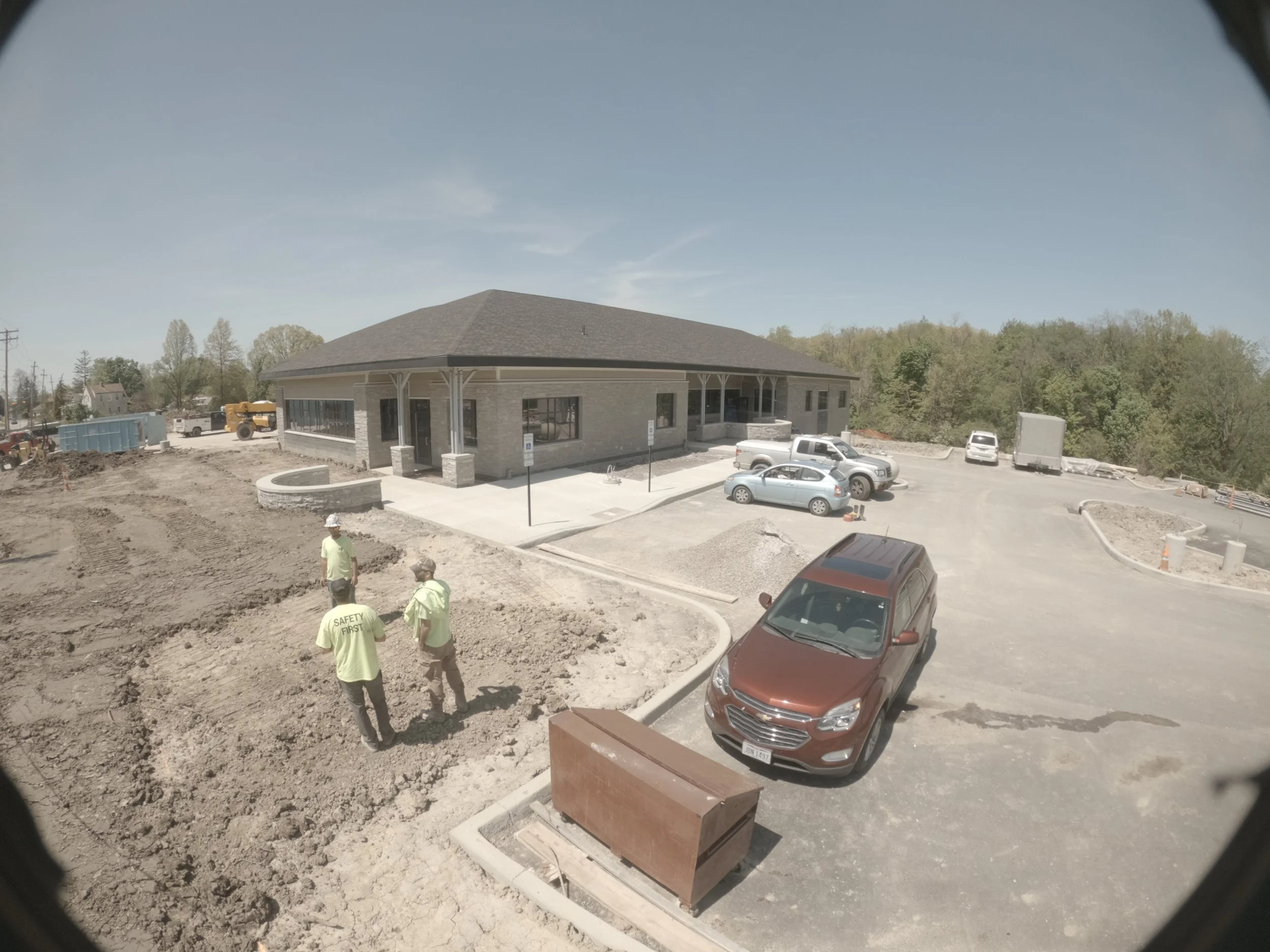
Aerial and Ground Photos and Videos
Capture high-resolution aerial and ground imagery at scheduled intervals to document site progress, verify milestones, and keep stakeholders informed in real time.
Useful for insurance purposes for worksite documentation and proof of work.
Consistent marketing content of the project, as well as before and after images and videos for website portfolio and RFP submissions.
-
Stationary Timelapse Cameras
Installed on-site to record every stage of construction, our timelapse solution provides you with remote access to collected visual records via cloud storage during the construction process.
Timelapse videos of the project from start to finish can be created for your marketing efforts.
-
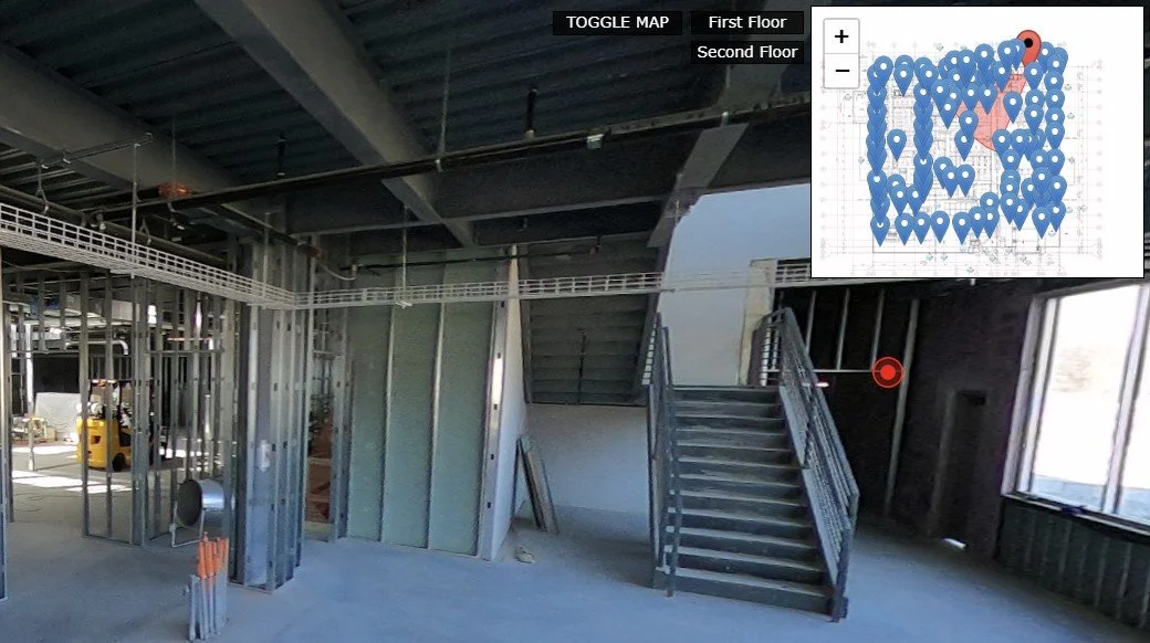
360 Walkthroughs with Plan Overlays
Interactive 360° site tours let teams and clients explore the job site remotely while comparing current conditions to design plans for accurate progress tracking.
-

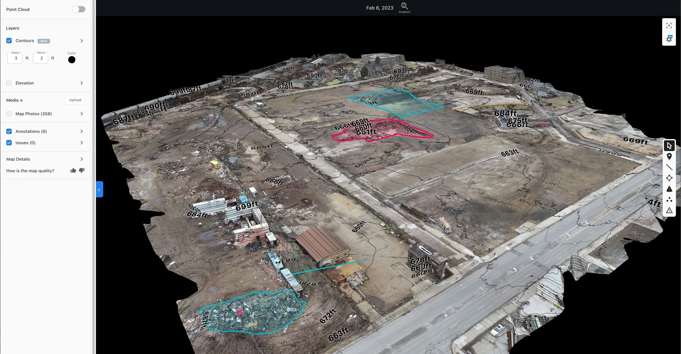
3D Models & Maps for BIM Comparisons
Aerial photogrammetry generates precise 3D models and orthomosaic maps that integrate with BIM software, enabling detailed analysis and as-built verification.
Mapping, Measurement & Modeling
Our drone mapping and modeling services deliver precise geospatial data that empower construction and engineering teams to make faster, smarter decisions. By capturing high-resolution aerial imagery and processing it through advanced photogrammetry software, we generate accurate site measurements, elevation data, and 3D visualizations that enhance project planning, tracking, and verification.
Stockpile Measurement & Cut/Fill — Obtain fast, accurate volume calculations for earthwork and materials using drone-captured imagery. Reduce the need for manual surveys, eliminate guesswork, and track quantities over time to control project costs.
Digital Elevation Models (DEM) — Visualize terrain changes and elevation data across your site to improve grading plans, drainage analysis, and infrastructure design. DEMs provide a reliable digital surface for engineers to plan and validate earthworks efficiently.
Point Clouds & 3D Animation — Generate high-density point clouds that convert your job site into measurable 3D space. These models enable precise as-built comparisons, clash detection, and immersive visualizations that enhance collaboration and client communication
Show your project from every angle - from site progress to project completion: Ground, Aerial & 360 Photos & Video, Virtual Tours, Drone Flythroughs
Construction Timelapse Video
Aerial Photo
Construction project video: combines stationary timelapse and aerial video upon completion
Project Completion Video
Controlled Demolition Documentation for Digital Marketing
Aerial & Ground Media for Marketing
Visual Inspections
Roof & Facade Inspections
Regulatory Compliance Checks
Pre/Post Insurance documentation
Asset Inspection (Rollercoasters, Cell Towers, etc.)

Asset Inspections
Trusted by AEC Teams Across Ohio and the Midwest
Our Customers
Our Customers
Geis Companies logo with stylized "G" and company name.
Logo of Premier Development Partners with blue building icon.
DLZ logo with globe and services like architecture, engineering, and construction.
Goettle logo with stylized green letter 'G' and text in bold font.

Logo with the word 'Racer' and a blue and yellow background design.
Pinnacle Construction and Development Group logo
Hecate Energy logo with a yin-yang symbol in blue, yellow, and brown colors.

CBRE logo

Cushman & Wakefield and Cresco Real Estate logos on a red background.

Colliers International logo with blue rectangle and colored stripes
Empire Paving logo with a triangle featuring a winding road graphic and yellow text.'

GBX Group logo with stylized globe graphic

Paul Schumacher Homes logo

Stylized TKG logo in black on white background
HSK Architects Engineers Logo
Why V1DroneMedia
-
10 Years in Business
-
FAA-Certified & Fully Insured
-
Founded by an Aviation Expert & Engineer
-
Based in Cleveland, Serving the Midwest
Resources for AEC Professionals - BLOG


Ready to Elevate Your Construction Workflow?
Let’s discuss how drone data, mapping, and marketing visuals can transform your next project