
Better Cost Estimates and Site Understanding Through Drone Technology: Your Construction RFP Guide
Ready to take the guesswork out of your construction project estimates? The right cost estimates make all the difference between project success and budget overruns. Modern drone technology delivers precise site analysis at a fraction of traditional surveying costs and time, giving you accuracy that manual methods simply can't achieve in the same amount of time.
Drone-powered photogrammetry gives project managers a clear view of construction sites from every angle - especially valuable for expansive projects where ground surveys fall short. Your team spots potential issues before they become problems, tracks daily progress, and makes smart decisions that keep projects on schedule. The added benefit? Drone surveys handle dangerous terrain safely, eliminating the risks tied to manual site inspections.
This practical guide shows you exactly how drone technology creates spot-on cost estimates for your construction RFPs. We'll walk you through smart ways to include drone data in your documentation, break down the real cost advantages, and share proven techniques to get the most value from your investment.
Incorporating Drone Data into RFP Documentation
Looking for crystal-clear RFP documentation? Drone technology delivers exactly that through GPS-referenced data collection and visual insights. That means better accuracy while significantly cutting documentation time.
Creating compelling visual presentations
Picture-perfect aerial photography and video captures every site detail, can give you professional 3D models and detailed topographic maps. Your RFP will stand out with stunning imagery, site maps that you can utilize for 3D renderings, helping give stakeholders a clearer picture of the finished project.
Demonstrating project understanding through aerial imagery
Expert aerial surveys can uncover the full story of your site - from elevation changes to drainage patterns and vegetation details.
Underground utility mapping and overlay techniques
Smart GPS drones follow carefully planned flight paths, taking hundreds of overlapping photos to build complete site models by utilizing drone photogrammetry. These models can pinpoint underground utility locations by working seamlessly with existing utility location data to deliver spot-on utility mapping reports.
Supporting cost estimates with precise measurements
Want measurements you can trust? Drone surveying delivers exceptional precision for volume calculations and material quantities. You can get:
· Volume measurements in minutes instead of hours
· Precision down to 1/10ft (3cm) for stockpile measurements
· Instant site condition updates through real-time data
This level of accuracy keeps your bids right on target, helping you stay competitive while protecting your profit margins.
Cost-Benefit Analysis of Drone Implementation
Ready to see the real financial impact of drone technology? The numbers tell a compelling story. Today's construction industry spends USD 8.00 trillion yearly, yet typical projects still run over budget and behind schedule.
Time savings in bid preparation
Think weeks of survey work - now done in hours. A 12-acre property survey shrinks from 100 hours to just 2 hours. Your team prepares bids faster, tracks progress more often, and handles more projects. The result? More contracts won and fewer project delays.
Using Drones Beyond RFP
Looking for precision in project tracking? Today's construction demands exact documentation at every stage. Drone technology captures crystal-clear aerial imagery, giving project managers unmatched site monitoring capabilities.
Maximizing ROI Through Strategic Drone Use
Want to see real returns on your drone investment? Smart implementation delivers exceptional results. Just ask Grade Tech - they employ the latest software that interfaces with our positioning tools to perform topographic and layout operations, advanced modeling programs, and modern job-tracking software to ensure efficiency at every stage of the project, cutting traditional survey times by 60-70%.
Project monitoring brings even bigger rewards, with drone use eliminating costly downtime.
Measuring and tracking cost savings
The proof is in the numbers - 92% of construction firms see positive ROI within their first year using drones. Your savings grow through reduced labor costs, minimal downtime, and precise measurements. The key to measuring drone use ROI? Careful tracking of every dollar saved across your project timeline helps fine-tune your drone strategy based on real results.
Construction Progress Monitoring for Project Management
Smart drone flights follow carefully planned routes, delivering consistent site documentation. Your project managers receive a focused package - 3-5 key images plus a 30-second video clip from each monitoring session. These visual updates spotlight potential delays or issues before they impact your timeline. Our clients catch inefficiencies early and adjust their strategies with confidence. Having an ongoing drone site capture schedule gives project manager and superintendent opportunity to request additional shots or data collection before a visit as needed for faster decision-making.
Client Project Updates with Drone Photos and Videos
Keep your stakeholders in the loop without site visits. Professional progress reports flow on a regular schedule, giving everyone clear insight into project developments. These detailed updates prove timeline adherence and milestone achievements to clients, and are especially helpful when clients are located out of state, or even out of the country (as was the case with one of our client projects).
Project Documentation for Marketing
Stunning aerial photography tells your project's story, highlighting its true scale and sophistication. Our clients use drone footage to:
· Build impressive time-lapse videos showing project progress
· Showcase sweeping panoramic views of projects for digital marketing
· Create winning portfolios for future proposals
The real power of drone technology lies in its versatility throughout your project's lifecycle. Your team can even upload raw footage directly to specialized construction software platforms, building a complete visual record of construction progress. Learn more about this topic in our Drone Use in Construction Marketing blog post.
Conclusion
Ready to take your construction RFP process to the next level? Drone technology delivers perfect cost estimates through exact measurements and detailed site analysis. Your team gains 90% better accuracy while slashing documentation time in half. Most companies see remarkable results in yearly savings and productivity gains over time, making drone technology a game-changer for modern construction management.
The path to success starts with committing to giving drone technology a try from the pre-construction RFP submission all the way to the completion of the project. The numbers will tell a clear story - while ongoing costs can average $5000-$20000 with consistent use of drone technology throughout construction project span (6-18 months usually), construction firms see positive returns within twelve months. Your tangible and intangible savings can grow quickly through streamlined costs, faster bid preparation, precise project monitoring, informed decision-making, improved client communication, and stunning marketing materials.
Want to see these benefits firsthand? V1Dronemedia offers a free drone photography and video shoot for your next RFP submission. Our expert team can also help you obtain accurate site measurement and mapping for better site visualization. Contact us to learn how you get your free drone shoot at the RFP stage!

How to Build a Business Case to Use Drones in Your Construction, Engineering, or Architecture Operations
So, you've heard and read that drones are being increasingly used in the construction industry to realize multiple benefits: they are utilized to complete some tasks in commercial real estate development and construction workflows faster, cheaper, safer, and in many cases, more accurate than using traditional methods. The latest construction industry reports show that drone use cases in construction are expanding, and the number of flights is increasing.
At this point, you may be already convinced that bringing drones, or at least testing the inclusion of drones in your operations is the right thing to do. The main problem you are facing is that you know that trying this technology will take additional resource allocation from your organization (it may be time, budget, manpower, or all the above). And if you don't control any of these resources but see the opportunity and are eager to bring this to your managers, you will need to build a business case and present it to your superiors.
At the end of the day, you also want to keep yourself relevant and further your career in your organization or even create a new position job for yourself, so proposing using cutting-edge technology to make your company's operations more efficient will promote your reputation as forward-thinking and innovative. If you do control the decision-making and resources in your organization, you can contact V1DroneMedia today, and we can help you find the right drone solution and help incorporate drones into your operations.

Building a business case
Steps on how to build a business case to incorporate drones into your operations:
1. Understand the gaps that your organization must fill to build up this capability. They are:
· Knowledge of national airspace regulations to gauge your ability to fly at any given site (resource allocation and cost – can be a drone pilot or drone operations manager)
· Part 107 licensed staff or contractors that can legally and skillfully operate drones to accomplish required tasks (staff allocation and training cost, or cost to hire pilots)
· Purchase drones that are suitable for your use cases (know-how and the cost)
· Drone equipment maintenance (know-how and the cost)
· Purchase Drone Insurance (unless your pilot contractors have it and can add your organization as an additional insured)
· Establish Drone Operating procedures on work sites
· Photogrammetry software (cost to purchase, human resources, and the know-how to process the data)
2. Establish use cases in current workflows that can bring value to your organization and translate them into cost savings, a competitive advantage, new added value, or other benefits.
See our blog posts Photogrammetry, Top 4 Drone Uses in Construction, Drone Use in Construction Marketing, Drone Mapping: Unleashing the Full Potential of Aerial Data, What is Drone Mapping, and Drone Mapping Advantages vs. Conventional Mapping Methods for information on a variety of ways to incorporate drones into your operations. Benefits of these use cases include, but are not limited to:
· Saving time in accomplishing tasks faster (translate that into saving $ as well)
· Providing more accurate data for some use cases (translate into $ savings)
· Potential for safety increase (can be one of the organizational goals, or translate it into insurance savings, or other $)
· Add new value to your operations (translate that into a new product/service offering as a new stream of revenue, new customer benefit to differentiate you from the competition, etc.)
3. Establish a budget range and other resources (like labor) necessary to acquire this capability.
You will also have to decide if you want to grow this capability from within, or outsource the data gathering and processing – i.e. Make or Buy decision)
4. Run financial analysis with multi-year scenarios to show the Return on the Investment (ROI) of implementing drone technology into your workflows
5. Develop a business case presentation that includes:
· Industry trends with drone adoption data
· Case studies of organizations that have adopted this technology (for example, see the article Ohio Department of Transportation Makes a Good Case for Their Drone ROI)
· Pros/cons of not adopting drones
· Outline your plan to build this capability for your organization
1. How your organization will use the drones
2. How drones will incorporate into workflows
3. What resource investment is required (budget and timeline for labor, hardware, software, insurance, etc.)
4. Financials with ROI. If you didn't have a financial professional from your workplace develop this model, make sure you can explain your assumptions. I recommend bringing a trusted finance team member on board to help you make the business case with concrete numbers
5. Present risks of adopting drones into your organization and plans to mitigate them
6. Finally, present your business case to your decision-makers.

Present your drone use business case
We hope you found this step-by-step guide on building a business case to include drones in your operations valuable.
V1DroneMedia is a Cleveland-based drone services company that was founded by an airline pilot with a background in remote control aviation and electrical engineering, and a marketing professional who has a couple of decades of experience in developing and pitching business cases to leadership (read more about V1DroneMedia here).
If you are looking for a consultant to help you include drones into your operation, help you train your employees to fly drones, build a business case, or are looking to outsource drone flying to a reputable company, contact us today, and learn more about our AEC Drone Services.

Drone Mapping: Unleashing the Full Potential of Aerial Data
Drones have revolutionized the way we capture and process data. Their ability to capture high-quality imagery and 3D models from the air has made them an indispensable tool for many industries, from construction to agriculture to environmental conservation.
While cost and time savings are two of the most commonly cited benefits of drone mapping, the technology offers so much more. Here are some of the other main advantages of drone mapping:
Precision and Accuracy: Drone mapping captures high-resolution imagery and precise location data, making it a game-changer for tasks that require precision and accuracy. For example, drones can capture detailed 3D models of a construction site, allowing architects and engineers to design with greater accuracy and detail.
Safety and Accessibility: Drones can access areas that are difficult or dangerous to reach, making them ideal for tasks like inspecting bridges or mapping disaster zones. By keeping human workers out of harm's way, drones can help save lives and prevent accidents.
Efficiency and Speed: Drones can cover large areas in a fraction of the time it would take a team of humans to do the same job (which is why many mention time and cost savings as the main benefit of drone mapping). For example, a drone can survey a large plot of land in a matter of hours, allowing construction companies or farmers to make decisions based on real-time data.
Real-time Data: Drone mapping can provide real-time data that can be used to make decisions quickly and accurately. This is particularly useful in emergency situations where time is of the essence, and drones are now a very useful tool for disaster response.
Environmental Monitoring: Drones can be used to monitor environmental changes over time. For example, they can capture images of forests to monitor tree density and detect signs of deforestation. This information, delivered in a timely manner, can be used to inform conservation efforts.
Planning and Design: Drone mapping provides architects, engineers, and urban planners with highly detailed and accurate data that they can use to plan and design more effectively. For example, a drone can capture a 3D model of a building site, which can be used to optimize the placement of equipment and materials.
As you can see, drone mapping is an incredibly powerful tool that can help organizations save time, improve safety, and make better decisions. With their ability to capture highly accurate and detailed data, drones can transform your workflows and allow a business to add more value to its operations, improving profitability and many other business metrics. Whether you're an architect, engineer, construction manager, or environmental scientist, drone mapping has the potential to unlock new possibilities and drive innovation in your field.
Please be aware that you should not fly drones or hire someone to fly them for commercial purposes without that person holding an FAA-issued Part 107 Certificate. If you want to learn if drone mapping is the right solution for your design problem or how it can add value to your business, contact V1DroneMedia for a consultation and demo today! We also offer drone training classes, and consultations on how to set up a drone program, if you are looking to bring this into your organization.
V1DroneMedia is a drone services provider based in Cleveland, Ohio, but we provide services anywhere in the United States. We service a variety of industries including construction, architecture, engineering, video production, marketing, and more!
V1DroneMedia's Chief Drone Pilot is a former commercial airline pilot and trained electrical engineer. Read more about V1DroneMedia.

What is Drone Mapping
Drone mapping, also known as aerial mapping or unmanned aerial vehicle (UAV) mapping, is the process of using drones equipped with cameras and other sensors to capture and process aerial imagery and data to create detailed maps, 3D models, and other visualizations.
How is drone mapping performed?
The drone flies over the area of interest and takes multiple overlapping images. These images are then processed using specialized software to create a detailed map or 3D model of the area.
Typically the process of drone mapping involves several steps: planning the flight, capturing the data, processing the data, and analyzing the data. Some of the key technologies used in drone mapping include photogrammetry (see our drone photogrammetry post to learn more), lidar, and thermal imaging. The outputs are usually in the form of Orthomosaic maps, 3D models, point clouds, and other forms of data that can be used for various purposes.
What can drone mapping be used for?
The maps and models created by drone mapping can be used for a wide range of applications, such as land surveying, construction planning and management, crop monitoring, and environmental conservation.
What are the advantages of drone mapping vs. traditional mapping methods?
Drone mapping can provide a cost-effective and efficient way to collect detailed data and imagery of large areas, including hard-to-reach places, and can provide a high level of detail not possible with traditional mapping methods. Read our Drone Mapping Advantages vs. Conventional Mapping methods blog post for more details (especially if you need to make a business case to use drones for mapping). See more details in our blog post Drone Mapping advantages vs. Conventional Mapping Methods.
How much does it cost to contract drone mapping services?
The cost of drone mapping can vary depending on a variety of factors, such as the size of the area being mapped, the level of detail required, and the equipment and software used. Typically V1DroneMedia charges for time on site, processing time, and software use, which varies on a project basis. This cost can range from a few hundred dollars for a small project to several thousand dollars for a large or complex project.
Who can use drone mapping services?
1. Agriculture: Drones can be used to create detailed maps of crops and fields, which can help farmers optimize crop yields and make better-informed decisions about planting, fertilizing, and harvesting.
2. Construction: Drones can be used to create detailed maps of construction sites, which can help contractors plan and execute projects more efficiently.
3. Real estate: Drones can be used to create detailed maps and 3D models of properties, which can help real estate agents market properties more effectively. Drones are also used to make informative listing videos and photos - you can read more about it in our Why Use Drone In Real Estate Photography and Video blog post
4. Surveying: Drones can be used to create detailed maps of land and structures, which can help surveyors and engineers plan and design projects more accurately.
5. Environmental monitoring: Drones can be used to create detailed maps of environmental features such as wetlands, forests, and wildlife habitats, which can help conservationists and scientists monitor and protect these areas.
6. Emergency response: Drones can be used to create detailed maps of disaster-stricken areas, which can help emergency responders plan and execute rescue and recovery operations more effectively.
7. Inspection: Drones can be used to create detailed maps of industrial plants, power lines, and other infrastructure, which can help organizations identify and address potential safety and maintenance issues.
These are just a few examples - drone mapping can be used for many other applications as well. V1DroneMedia provides drone mapping services and more AEC Drone Servies in Ohio and other Midwest states. Read about our founders who brought a combined 40 years of aviation and business experience to start V1DroneMedia.
Contact us if you are looking for a drone mapping project consultation or a quote. Don’t forget that in order to perform drone mapping one has to hold FAA Part 107 commercial drone certificate, and be aware of and comply with the FAA airspace regulations for the area where the drone mapping missions are flown.

Façade Inspections in Cleveland by Drone
Why Building Façade Inspection is Needed
A municipal ordinance was passed in 2016 in Cleveland, Ohio, to require façade inspections for buildings of certain age and height to be completed every 5 years – see the detailed ordinance here. Since this ordinance was passed in Cleveland, 2 other major Ohio cities, Columbus, and Cincinnati followed with passing similar ordinances the same year.
As with most ordinances, Cleveland's ordinance passing was a direct consequence of an accident: a parapet wall of an 1890s-era building in downtown Cleveland crumbled, releasing several bricks onto the sidewalk and the road, thankfully without human casualties this time (a parked minivan without passengers was damaged).
The ordinance that was passed requires buildings that are at least 5 stories or 75 feet in height above grade and are of a certain age (between 30-50 years old), to be initially inspected and re-inspected every 5 years.
How was the building façade inspections performed in the past
In the past, this type of inspection was done by inspectors needing to get close to the walls to visually inspect them and document the conditions, which meant erecting and installing the scaffolding, or elevating them by another method, which gets the person close to the source of inspection, but it is not very efficient:
1. It takes time for them to move within the scaffolding, or be elevated by a crane platform to every spot that needs to be inspected and documented
2. It is not the safest for the person involved (a falling accident is a possibility)
3. It can be expensive with the time and equipment involved, plus the addition of insurance costs when performing this work at dangerous elevations.
These types of inspections can be costly to complete when using traditional methods. Facade inspections can run into $10K-$20K, depending on the size of the building. The cost is usually made up by using large equipment or erecting scaffolding structures, inspectors' time that is necessary to visually inspect and document the conditions of the asset, and the report write-up within the guidelines of such inspection.
As one can see, a large proportion of the cost of such inspection is driven up by the resource and time used to visually inspect and document current conditions effectively. The use of autonomous inspection tools that don't require the investment of such resources can cut costs drastically. Drones do just that for such use cases as facade inspections.
Why Use Drone For Building Façade Inspection
A drone allows for the faster and safer acquisition of the visual inspection and documentation data of the current conditions of the façades. Equipment and personnel need is reduced to a drone capable of shooting hi-res photography, and a drone pilot who is qualified to fly safely and legally and can produce such photography.
This photographic output generated by a drone can then be viewed by a qualified design professional on their computer (engineer or architect), certified in the inspection of the specific elements that make up the façade of the structure, and licensed by the State of Ohio, or an inspection agency that is qualified under the Ohio Building Code for Special Inspectors (as per the ordinance).
In addition to basic aerial photography, drone imagery can be set up to be acquired with certain parameters (automated flight path and special photography settings) with an intent of being processed through software to generate point clouds and 3D models, that help capture the building condition overall. Such models allow the inspector to zoom in at any point for a closer look during the inspection, and even produce measurements between points for needed calculations. These models can be stored digitally and updated with a new model at any point in time.
Looking to hire a drone company for a façade inspection in Cleveland?
If a company considers hiring a drone pilot to perform a façade inspection data capture (whether the building facilities management, an inspector or agency), it will need to do its due diligence - see our article Hiring a Drone Pilot for details on how to do that, or contact us to provide you with the quote to perform façade inspection data capture by one of our skilled drone pilots.
If you want to train someone within your organization to fly drones to capture such data, check out our drone training page for drone training classes offered in Cleveland, and contact us to schedule, or sign up for our drone class notification list.

Drone Use in Construction Marketing
The use of drones in construction is growing rapidly, with companies in this industry using drones for various tasks throughout the construction process. We count several construction companies as our clients, and here we are breaking down the uses of drones and other tools for construction services marketing.
The most common use of drones in construction is for marketing, because aerial photography and video showcase project site progress, action on the site, and the finished project better from the bird's eye view than from the ground. You can see more from the aerial view and show off the scale of the project, and the best way to get this type of content is to have ongoing construction progress documentation using drones.
How do construction companies use drone photography and video for construction marketing?
Social Media Content
Construction aerial photography and video generate great content to showcase the progress on the construction site to stakeholders and the public. They can also be used as early-stage marketing for the brokers if the building needs to be leased by tenants. Below are some examples: before/during photo and video clip that was posted on social media by our clients.
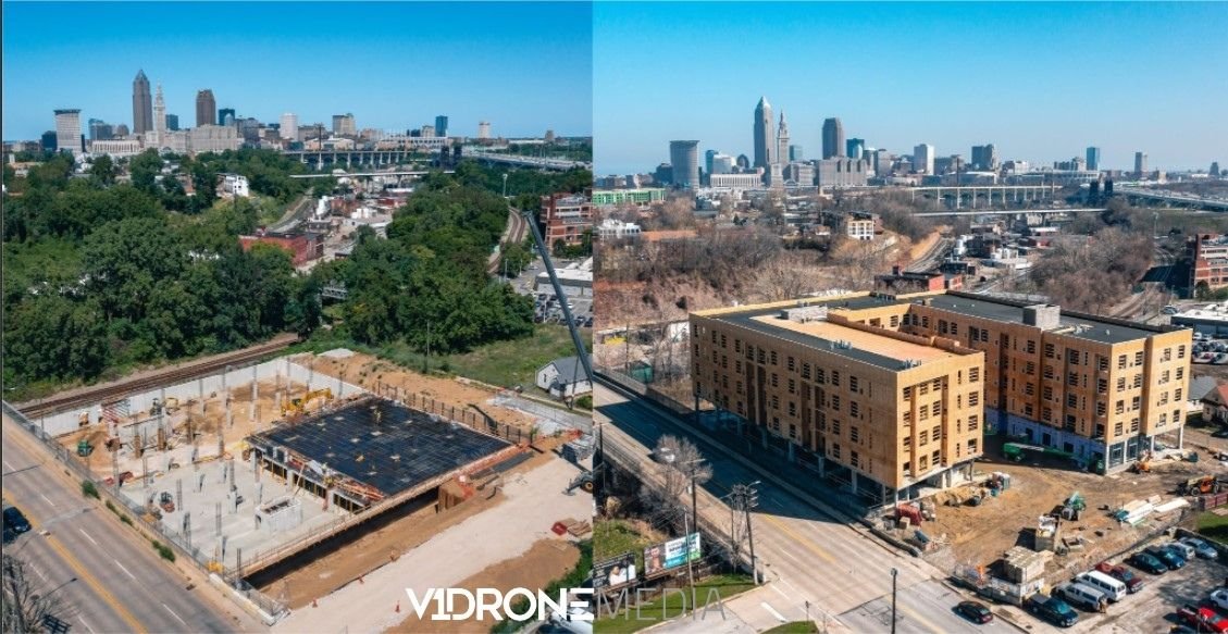
Before/During drone photo of a construction site on West 25th Street in Cleveland
2. Project Portfolio Showcase on Construction Company Website or YouTube Channel
Every construction company should have a section on their website to showcase the projects that they have been involved in. What better way to showcase them than with photos or videos of finished projects, maybe even an impressive hyper-lapse or timelapse video of the building going up during the construction?
3. Customer Proposals, Presentations, Business Development
While not all scopes of work require to have visual updates of the construction site, having this type of deliverable throughout the construction process may enhance your proposal, and even take it over the top all things being equal among the other bidders. Especially if the construction client is not local, which is often the case.
We have a construction client whose building owner is overseas, and having consistent visual updates is very valuable to them. It gives transparency and increases their confidence and trust in the builder.
4. Video Web Banners on Construction Company's Homepage
Have you heard that the website homepage, which is most often the landing page, is the most important page to optimize the content on because it gets the most traffic, and that's where the visitors decide if they want to browse further? A video banner of prominent projects that the construction company has built will impress many viewers and increase their confidence and motivation to take the next step: browse more or contact the builder. Here is an example.
Video is becoming a very important part of marketing strategy for many industries, including construction marketing strategy. If you'd like to know more about the reasons why read our blog post Why Is Video Important For Your Marketing?
What is the Return on Investment (ROI) of construction site progress monitoring and documentation?
Many construction companies leverage drones and other visual technology tools for more than just marketing, such as for enhancing customer communications, internal project updates, construction site security, and re-creating the built environments in BIM (Building Information Modeling) and creating digital twins.
In addition to drones, these tools are time-lapse cameras and 360 virtual tours. The visual output of these tools over the lifecycle of the project can be used and reused for various purposes, which can make the acquisition cost of construction site imagery very efficient, and its Return on Investment (ROI) increases with every use.
These tools are within the digitization trend in construction, facilities management, and other industries. This imagery can be used to re-create the built environment in 3D in BIM (used for construction and design) or as digital twins (usually used for facility maintenance and operations) to give companies a complete 3D visual model of the build. It is a digital documentation record that can be accessed at any time to send information about the building, reflect changes with its physical counterpart, and allow for materials ordering and scheduling (in the design/construction stage or for maintenance and expansions if the building is operational). These types of digital models can replace final building drawings and operations manuals.
We outline more drone uses on construction site on our blog post Top 4 Drone Uses in Construction Site Management.
If you'd like a quote for construction progress monitoring job or consultation on what equipment is best to use on your construction site for a specific purpose or a variety of uses, contact us!

Drone Photogrammetry And Its Uses
What is Photogrammetry
Photogrammetry is the science of making precise measurements of three-dimensional objects and terrain features from two-dimensional photographs. The input to photogrammetry is multiple photographs of some real-life object or a scene, taken from different angles and locations, and the output is typically a map, a drawing, a measurement, or a 3D model of the subject matter.
How does photogrammetry work?
This process works by using the method of triangulation. It involves taking pictures from a minimum of two different locations. These pictures create lines of sight that lead from each camera to specific points on the object being photographed. The intersection of these lines plays into mathematical calculations that help produce geometric 3D coordinates of the specified points, which sometimes is referred to as “point cloud”.

Photogrammetry triangulation creates 3D object
Photogrammetry history and evolution
Photogrammetry is nearly as old as photography itself. Since its development approximately 150 years ago, photogrammetry has moved from a purely analog, optical-mechanical technique to analytical methods based on computer-aided solutions of mathematical algorithms, and now to digital photogrammetry based on digital imagery and computer vision, without any mechanical hardware.
Topographic map creation was the first application of photogrammetry, which gave way to the development of simple map-making techniques geared towards the mapping needs of the military during World Wars I and II.
Types of Photogrammetry
Two general types of photogrammetry exist aerial (with the camera in the air) and terrestrial (with the camera handheld or on a tripod).
Terrestrial Photogrammetry
The photos used in photogrammetry can also be taken directly on the ground or from a fixed terrestrial position, such as by a person walking around or a camera mounted to a building.
Aerial (Drone) Photogrammetry
Aerial photogrammetry was introduced with the invention of flight, and drone technology advancements in the last 6 years have made it more accessible and affordable.
Now a drone captures several high-resolution photos over an area at different angles from multiple vantage points. These images are then processed with photogrammetry software (such as Pix4D, AgiSoft, Drone Deploy, etc.) that “stitches” the images together to create point clouds.
Photogrammetry accuracy
Several variables affect the overall accuracy of an aerial map, including camera specifications, the number of photos collected, the photo overlap percentage, the flight altitude, atmospheric conditions (wind speed, air pressure, air density, cloud cover, position of the sun), the GPS signal strength, and the ground sampling distance (GSD). A lower flight altitude yields a smaller GSD, and a smaller GSD yields a more accurate and higher resolution aerial map.
Many of these factors are already accounted for by main drone manufacturers that produce drones for collecting visual data used for photogrammetry processing. These drones are equipped with proper cameras, and the differences between those drones are oftentimes the quality of the camera itself, and the experience of the drone operator in using the drone for photogrammetry data collection (programming the flight path, calibrating, camera settings, etc.)
Relative and absolute photogrammetry accuracy
In aerial photogrammetry, there are such terms as relative (local) accuracy and absolute (global or spatial) accuracy.
Relative accuracy is the measurement of how objects are positioned relative to each other in a reconstructed model (Orthophoto map, Digital Surface Model, or 3D point cloud). Most aerial maps provide a high degree of relative accuracy. So, for simple use cases (measuring distances, volume, and height differences, etc.) relative accuracy should work just fine.
Absolute accuracy refers to the difference between the location of the objects on the reconstructed model and their true position on the Earth (or a geodetic coordinate system). Aerial maps do not provide a high degree of absolute accuracy unless Ground Control Points (GCPs) are used during the drone aerial data collection.

Relative vs. absolute accuracy
What are Ground Control Points (GCPs) in photogrammetry?
Ground control points are points on the ground with known ground coordinates, which can be easily recognizable in aerial photos. The ground coordinates can be measured with traditional surveying methods or an existing map (even Google Earth map), or smart control points that automatically upload position data, such as Aero Points. To calculate the coordinates for each point on the aerial photography several ground control points’ coordinates should be in place in the survey area and they should be clearly visible in the taken aerial photographs.

Ground Control Point Positioning
Drone Photogrammetry Outputs
The photogrammetry software generates object or area point clouds that enable data visualization, turning these clouds into various outputs for different applications, with many allowing for measurements such as distances, heights, areas, and volumes:
Orthomosaic maps are stitched from multiple drone photos that have been corrected for lens distortion, with each pixel containing 2D geo-information (X, Y) which enable the generation of measurements such as horizontal distances and surfaces.

Orthomosaic Map
Topographic maps show details of the relief features using contour lines (connecting points of equal elevation), giving a better understanding of the surface of the area.

Topographic Map
3D Point Cloud is generated from drone images with each point containing geospatial (X, Y, Z) and color information. It provides a model for distance, area, and volume measurements.

3D Point Cloud
3D Model is often generated from the 3D Point Cloud, and is a reproduction of the edges, faces, vertices, and texture of the object or area shot by the drone, and is most useful for visual inspection. This type of model can be used in CAD (Computer-Aided Design) or BIM (Building Information Modeling) software.

3D Model Screenshot
Digital Surface Model represents the elevation associated with the surface of the earth including topography and all human-made features, containing 2D information (X, Y) and the altitude (Z) of the highest point for the area.

Digital Surface Model
Digital Terrain Model (also Digital Elevation Model) is a topographic model representing the bare ground surface without any objects like plants or buildings and can be uploaded into and manipulated by computer programs. The model contains 2D information of the area.

Digital Terrain Model. Credit: Jason Stoker
These outputs can be used in many applications in various industries, where the workflows for the collection of this type of data were largely manual and time-consuming. With drone photogrammetry productivity and efficiency of such operations can be improved significantly, and allow for more opportunities to innovate with such easy access to digitized data.
If you are interested in learning more about drone photogrammetry and its applications for your business, Contact us for a free consultation!

Top Drone Applications in Construction Project Management
Many people don't think of drone uses beyond military applications or taking aerial pictures and video for professional photographers, videographers, and filmmakers. The truth is many industries are adopting this multi-use tool at very fast rates, and using drones for construction project management and site visualization is a top trend in the construction industry, according to Project Manager News.
Here are the top 4 drone uses for construction projects
1. Construction Project Management via Construction Site Visualization
Drone photos and videos taken and shared at regular intervals for construction monitoring to verify progress, changes, and comparison vs. design documentation can improve communication and decision-making between the construction project management team members. When they are looking at the same pictures or video vs. written or verbal reports from several people walking the construction site at different times, there is a lot more clarity and agreement on the state of the site's progress, leading to faster problem identification and decision-making.
360 video and photo technology, when combined with drones can help produce virtual construction site tours (with interior and exterior of the building, see our example here) that can be used for touring the site virtually by team members, customers, or owner's reps, which gives transparency on the project progress, can help resolve conflicts, and speed up decision making.
Site mapping using drone photogrammetry software can be performed in all stages of construction, overlaying processed drone site maps with site plans for utility, wastewater, equipment location, etc.), helping with planning and managing the site.
2. Drone Inspection (Building, Façade, roof, Equipment)
Remote drone inspections performed by qualified drone pilots can replace hours of human time spent inspecting and tracking the state or location of equipment, structures, and critical assets, decreasing the likelihood of employee accidents and human error when gathering this data visually by walking the site or climbing structures, leading to a more efficient, safer, and cost-effective operation.
Proven drone photogrammetry scanning software such as Drone Deploy, Pix4D, AgiSoft (and others) offer tools to upload and process point cloud data gathered by a drone pilot in a matter of hours, giving real-time actionable information in form of hi-res images and digital twins of structures (3D aerial photogrammetry models) for someone to conduct an inspection in the safety of their office, and provide collaborative tools for the construction team to document photographic evidence and make notes on "problem" areas.
3. Construction Site Documentation
You can document as-built conditions upon the completion of the project via panoramic photo and video virtual tours, site maps, and 3D model creation that can be integrated into BIM (Building Information Management) and MEP (Mechanical, Electrical, and Plumbing) documentation.
Many photogrammetry drone software tools also offer integration of processed data (aerial maps, 3D models, etc.) with leading construction management software platforms, making the incorporation of this technology into existing workflows easier.
4. Construction Services Marketing
It is well-documented that aerial photos and videos of construction sites are some of the best ways to market construction services. Construction site drone photos and videos can be used in customer presentations, websites, and social media to showcase progress and finished projects that give the firm credibility and get prospective customers excited about a potential partnership. What can be more gratifying and exciting than seeing a building which took months, if not years to build, go up in a Hyperlapse video in less than a minute?
Finally, the ability to provide construction site visualization and progress reports via photos, video, and virtual tours can be an additional way to make your construction company stand out among competitors when bidding for a construction project, as that's an additional value you are providing with multiple customer benefits.
We at V1DroneMedia specialize in providing safe, legal, and high-quality aerial drone services in and around Cleveland, Ohio, to various industries, including construction. Check out V1DroneMedia Drone Construction Services and Contact Us for a consultation or a project quote.